Welcome

The survey and recent public comment period for the project is now closed

Thank you to everyone who provided input on the cost saving measures! The project team is now reviewing input received to inform the next steps in the project. This online open house will remain available for your information and reference until the project team has more information to share. To sign up for project updates, please use the form at the bottom of this page.

Help us plan the first earthquake ready bridge in downtown Portland

Experts say there is a one in three chance of a magnitude eight or greater earthquake occurring in our region within the lifetime of most Oregon residents. Portland’s aging downtown bridges are not expected to withstand such an earthquake and it could be weeks before any downtown bridge is usable. That’s why Multnomah County is taking the lead on making at least one downtown crossing earthquake ready.

Located in the heart of downtown and on a designated regional lifeline route, a resilient Burnside Bridge will play a critical role in emergency response, rescue and economic recovery following a major earthquake. The existing bridge is nearly 100 years old and approaching the end of its service life. A new Burnside Bridge will support our transportation needs for the next century.

Where are we now?

The project is currently in the Environmental Review Phase. In late 2020 and early 2021, we asked for your thoughts on the initial recommended Preferred Alternative. With the recommendation from the Community Task Force and over 88 percent support from a community survey, the Replacement Long Span was identified as the best option to move forward since it is best for seismic resiliency, has the lowest cost, and least environmental impacts. In early 2021 we also asked for your thoughts about the type of long span bridge that should be constructed, including consideration of girder, truss, cable supported and tied arch options, as well as bascule and lift options for the bridge’s movable span.

Additional engineering and cost estimating work completed in spring 2021 raised concerns among County leaders about the project’s cost. Recognizing rising costs due to current economic conditions and competition for funds from other large projects in the region, County leaders asked the project team to analyze ways to reduce the cost so the project is more likely to be funded and built. After further cost analysis, environmental and permitting analysis, and input from stakeholders, the project team identified three key refinements to the initial Long Span Preferred Alternative for the community to consider.

Environmental Review and Type Selection: 2019 - 2022

  • Jan./Feb. 2021: Receive input on bridge type options  
  • Feb./Mar. 2021: Publish Draft Environmental Impact Statement (DEIS)   
  • Sept./Oct. 2021: Update project cost estimate  
  • Nov./Dec. 2021: Evaluate and receive input on cost saving measures (We are here)
  • Mar./Apr. 2022: Publish Supplemental DEIS 
  • Sept. 2022: Publish Final EIS and receive Record of Decision

Design Phase: 2022 - 2025

  • Late 2022/Early 2023: Recieve contractor input on the east approach span

Construction Phase: 2025 - 2029

Click the plus signs throughout the Online Open House to learn more about each topic.

Reducing cost

Reducing the cost is key to getting the project funded and built

Cost considerations for the initial project have changed over the last year with the failure of the 2020 Regional Transportation Bond Measure which would have allocated $150 million to the project, high competition for funding of large infrastructure projects, and increasing labor and materials costs that emerged during the COVID-19 pandemic. Despite these challenges, the need for an earthquake ready bridge to serve the Portland region remains and Multnomah County fully supports completing the project. The team is now working to reduce project costs to help ensure this project can be fully funded and built.

Refinements to the Preferred Alternative could save roughly $200 million, resulting in an estimated cost range of $825 to $915 million. This estimate range, which is highly dependent on how the economy rebounds from the current COVID-19 price spikes impacting all transportation projects, will be refined and narrowed during the Final Design phase as more information becomes available.

The County currently has access to about $300 million for the project from local vehicle registration fee revenue. To make up the gap in funding, the County is actively working to secure funds from local, state, and federal sources – including President Biden’s proposed infrastructure package.

Refinement 1: Bridge width

Reducing overall bridge width to save up to $150 million

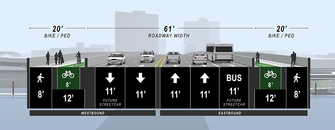
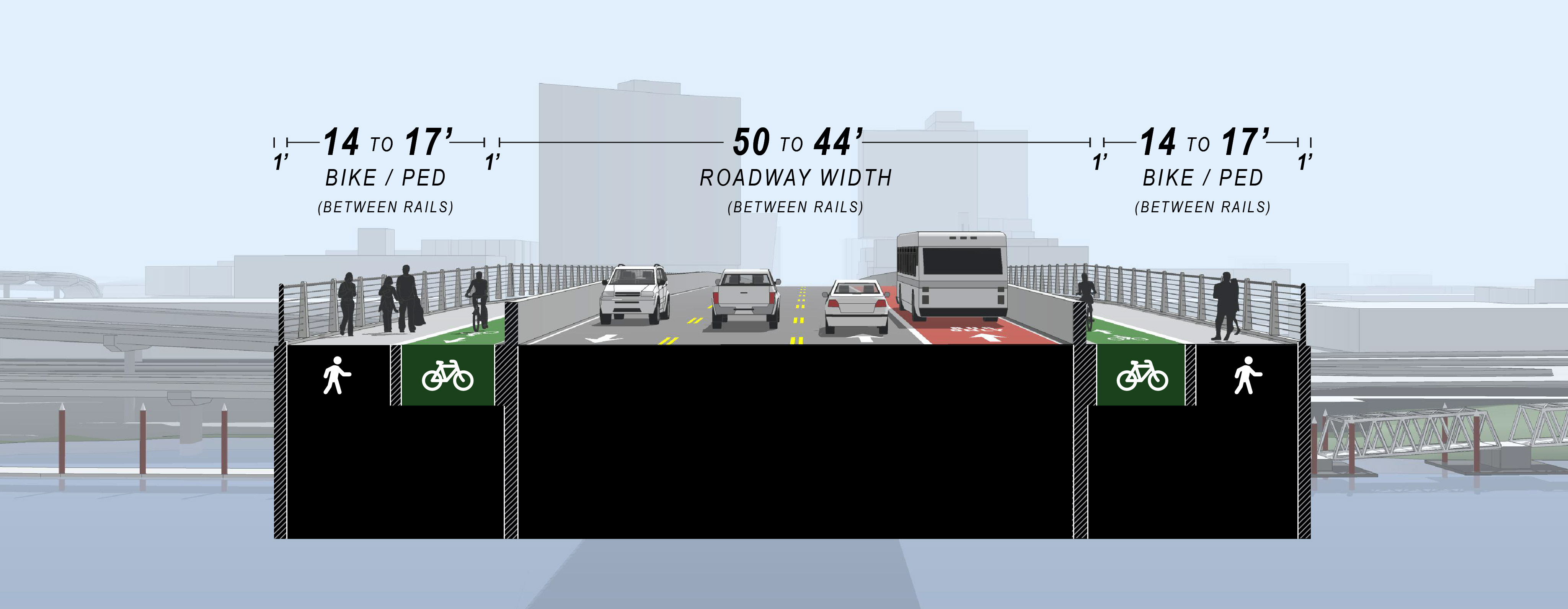
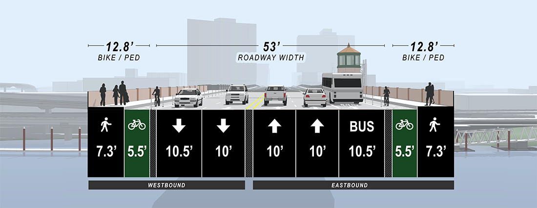
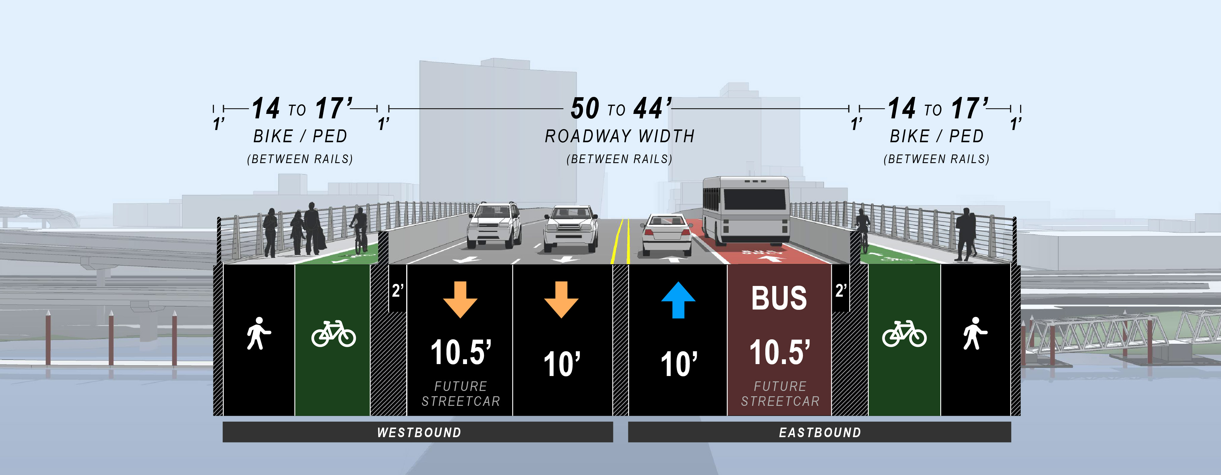
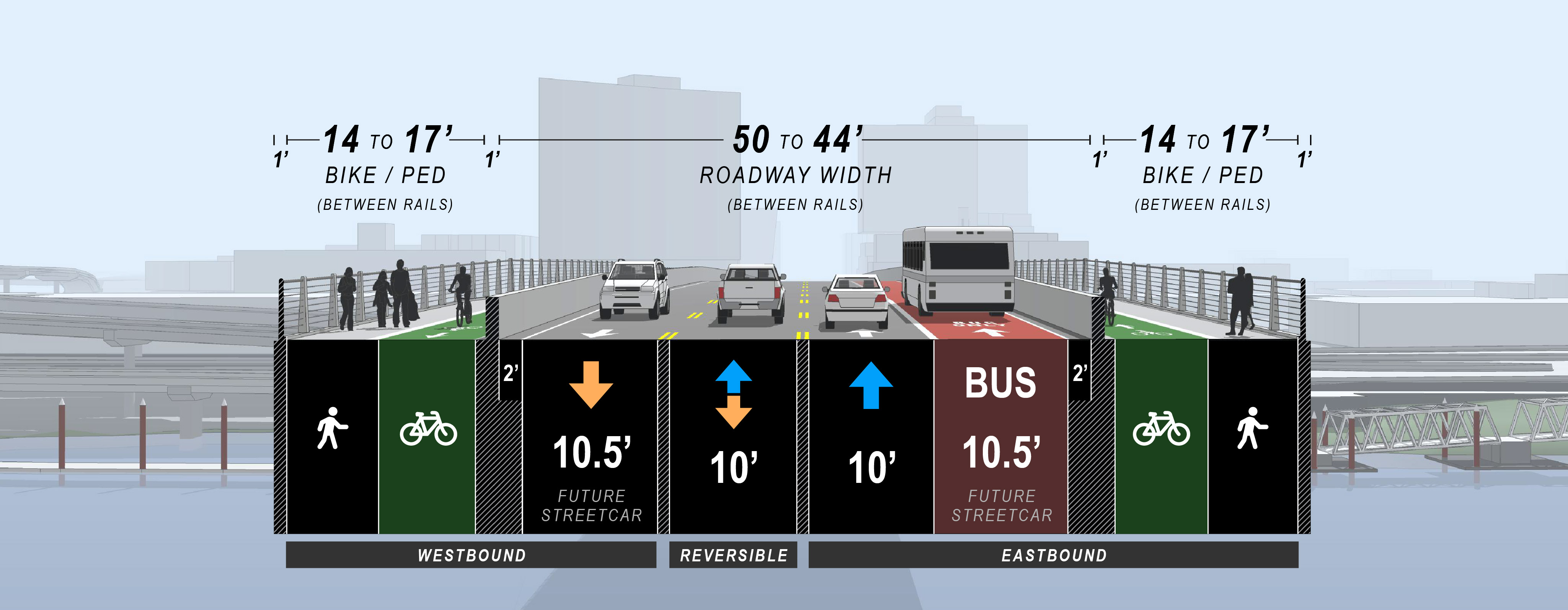
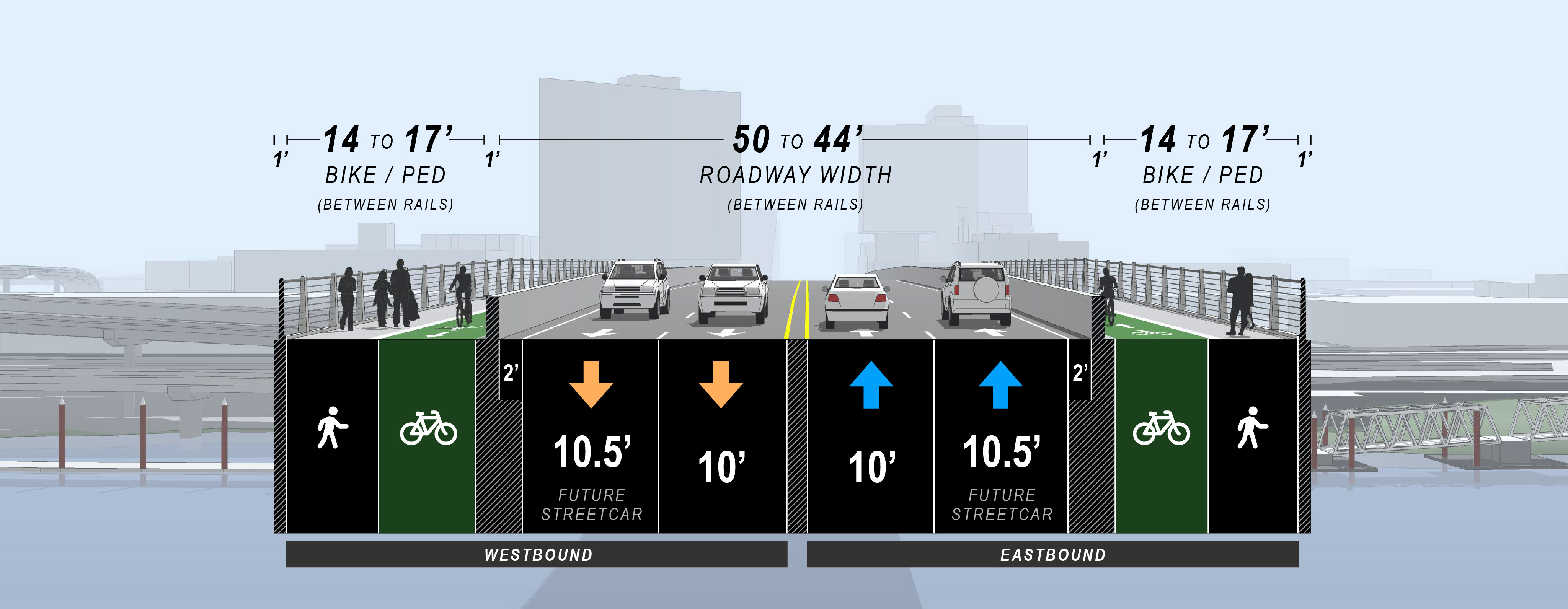
The project team recommends reducing the width of the bridge compared to the initial Preferred Alternative. The new bridge would be roughly the same width as the current bridge but with one less vehicle lane. Pedestrian and bike facilities would be narrower than the initial Preferred Alternative, but still wider than the existing bridge, and would be protected by crash-worthy barriers in both directions. Reducing the overall width of the bridge compared to the initial Preferred Alternative could save the project up to $150 million.

Proposed Roadway Width

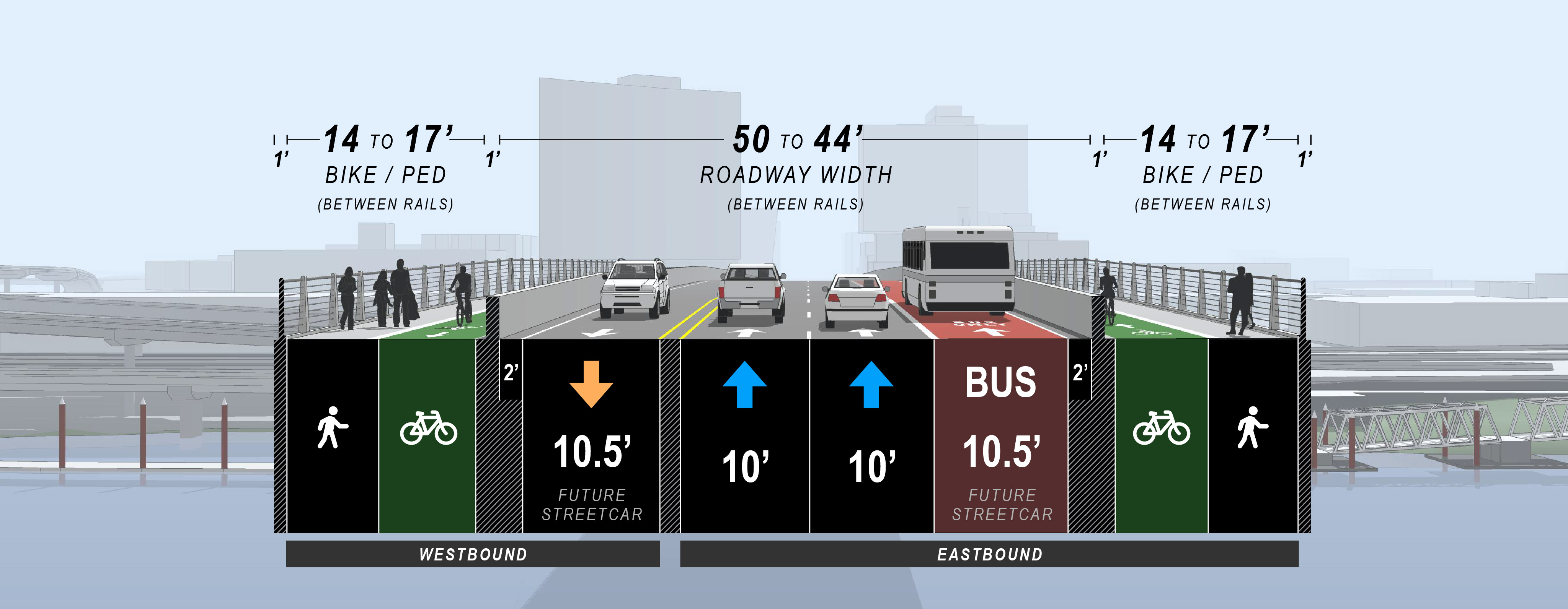
The project team proposes reducing vehicle lanes from five to four lanes to reduce costs. Depending on the exact lane and shoulder widths used, this would reduce the roadway width by up to 17’ compared to the initial Preferred Alternative and has the potential to result in traffic congestion on and approaching the bridge. Four different concepts for allocating the 44 to 50-foot space for vehicles in the revised Preferred Alternative were analyzed for impacts to traffic congestion during peak hours on the Burnside Bridge, other downtown bridges, and to transit. Review the vehicle lane allocation options section below to learn more about the traffic impacts for each option.

Although the project’s Community Task Force members almost unanimously supported the girder structure type for the west approach and the bascule structure type for the movable span, they were divided regarding narrowing the bridge width, with some expressing strong concerns for reducing the bridge from five lanes to four. Many of the members urged the County to incorporate a fifth vehicle lane should adequate funding become available.

Initial Preferred Alternative

A digital view of the Original Preferred Alternative, showing the Burnside Bridge widened to provide 61 feet for four vehicle lanes – two lanes Eastbound and two Westbound and one Eastbound bus lane. 20 feet of space is designated for bike and pedestrian lanes. Crash-worthy barriers separate pedestrian and vehicle lanes in both directions. 

Revised Preferred Alternative

A cross section of the Burnside Bridge shows 44 feet of vehicle roadway and 17 feet of bike and pedestrian space.
Example image showing lane configuation Option 3

Existing Bridge Width

A digital view of the Burnside Bridge cross section showing the existing bridge width (78.6 feet). 53 feet contributes to roadway width and 12.8 feet contributes to bike and pedestrian lanes in each direction on the bridge. There are 4 vehicle lanes – two lanes Eastbound and two Westbound. A designated bus lane is provided Eastbound.

Open the drop down sections below for more information on the four options for vehicle lanes.

Vehicle lane allocation options

Proposed Bike/Ped Width

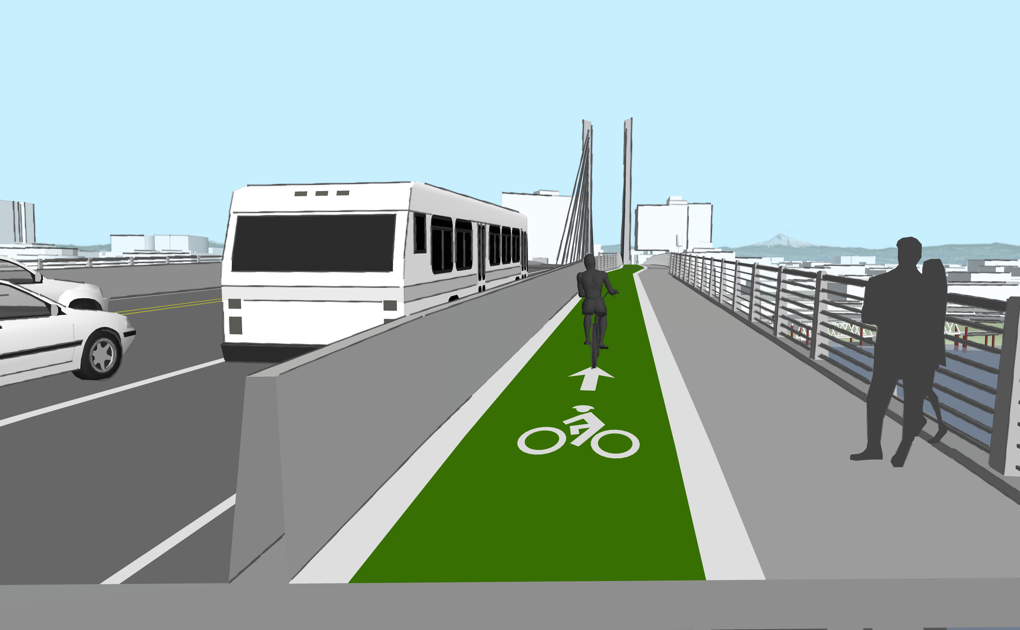
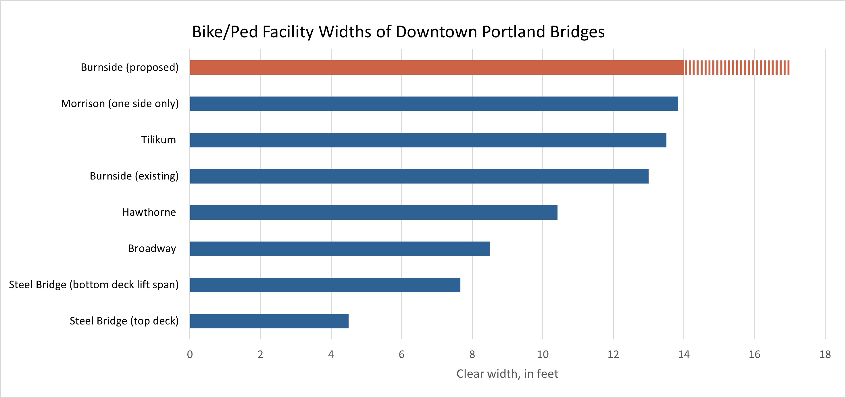
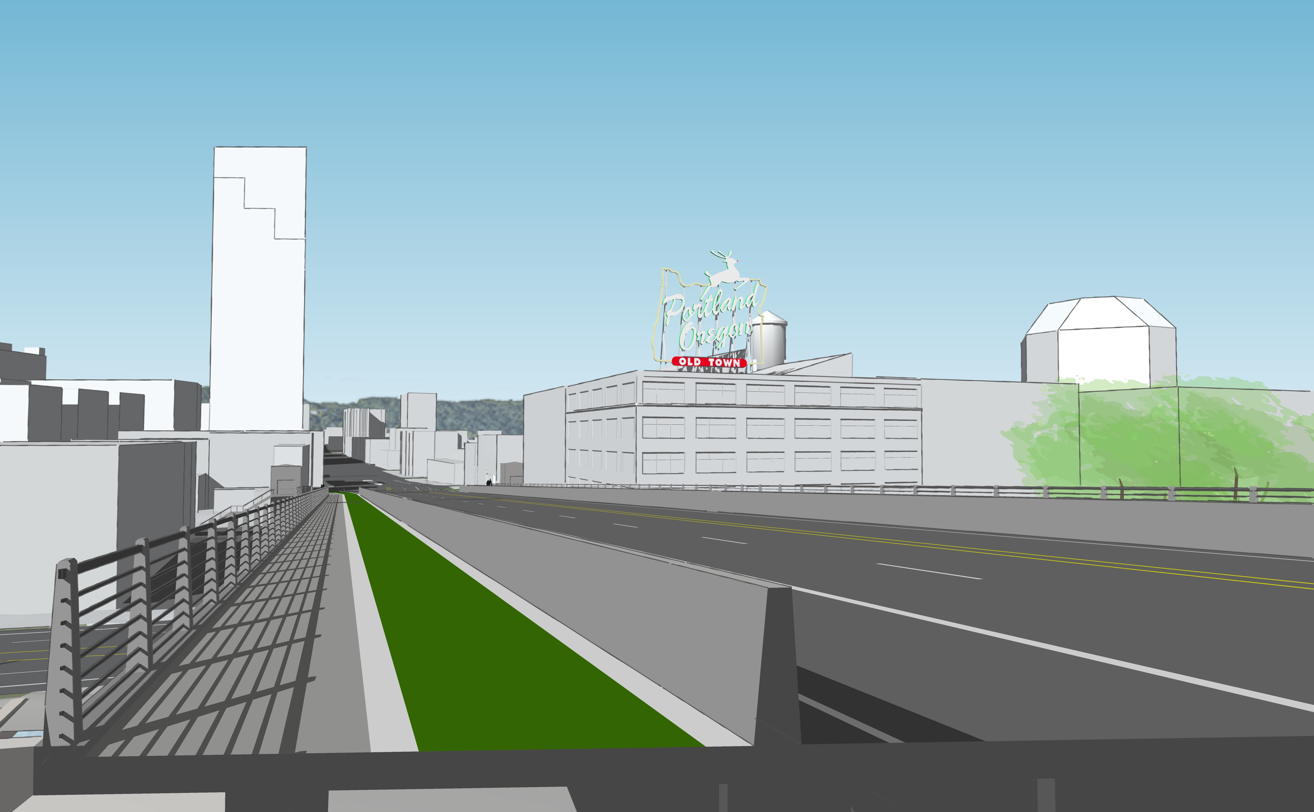
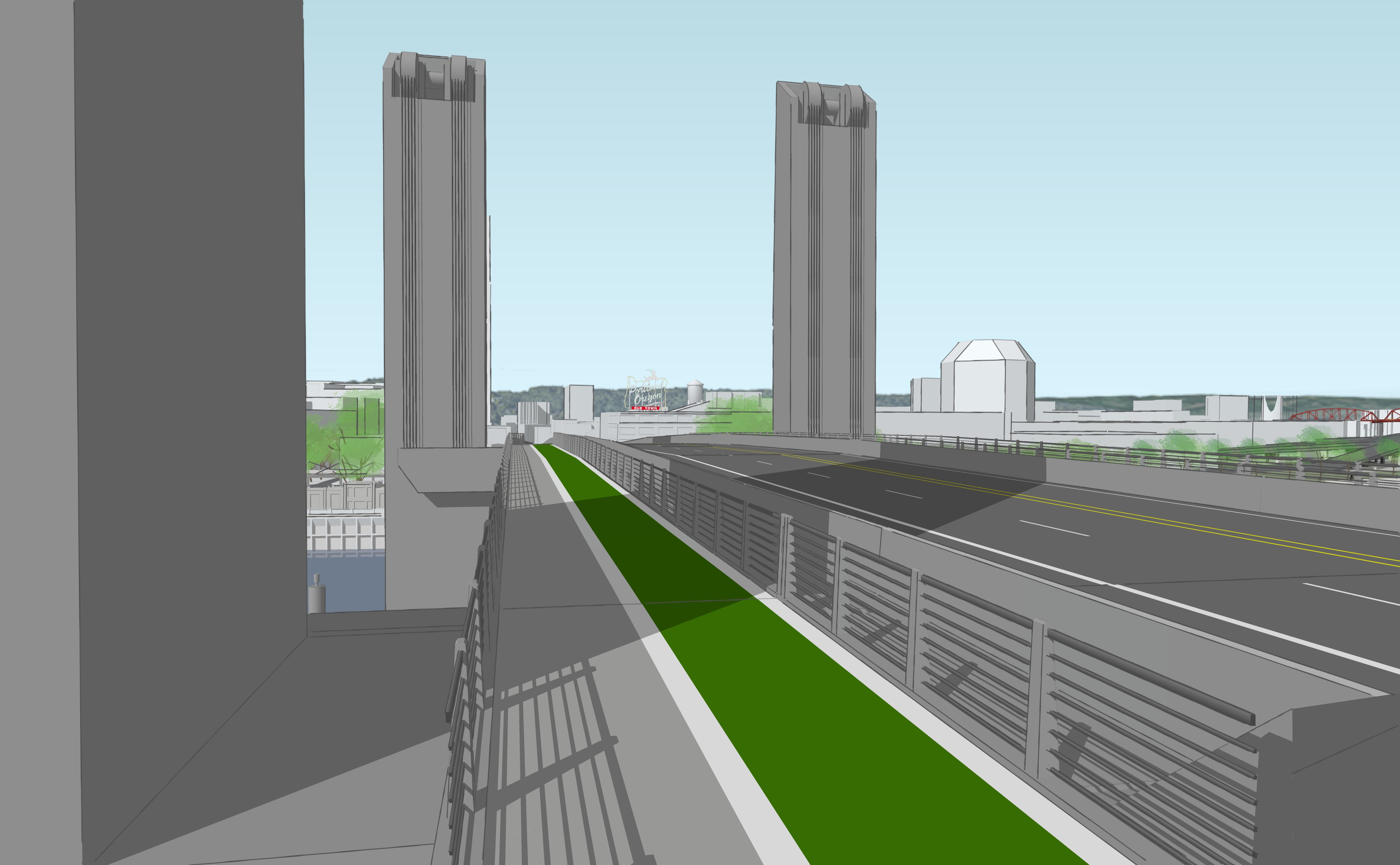
The revised Preferred Alternative includes bike and pedestrian facilities of 14-17 feet in width on both sides of the bridge. This would be wider than those on the existing bridge at 12.8 feet, and wider than those on any other downtown bridge. However, this is a reduction from the initial Preferred Alternative studied which would have allocated 20 feet for bike and pedestrian facilities on each side of the bridge.

Crash-worthy barriers between traffic lanes and the bicycle/pedestrian facilities on both sides of the bridge would remain in the design to provide increased safety and protection.

A cross section of the Burnside Bridge shows 44 feet of vehicle roadway and 17 feet of bike and pedestrian space.

Click the drop downs to learn more about the impacts and tradeoffs of adjusting the bike and pedestrian space.

Refinement 2: West side girder

Refined girder structure on west side

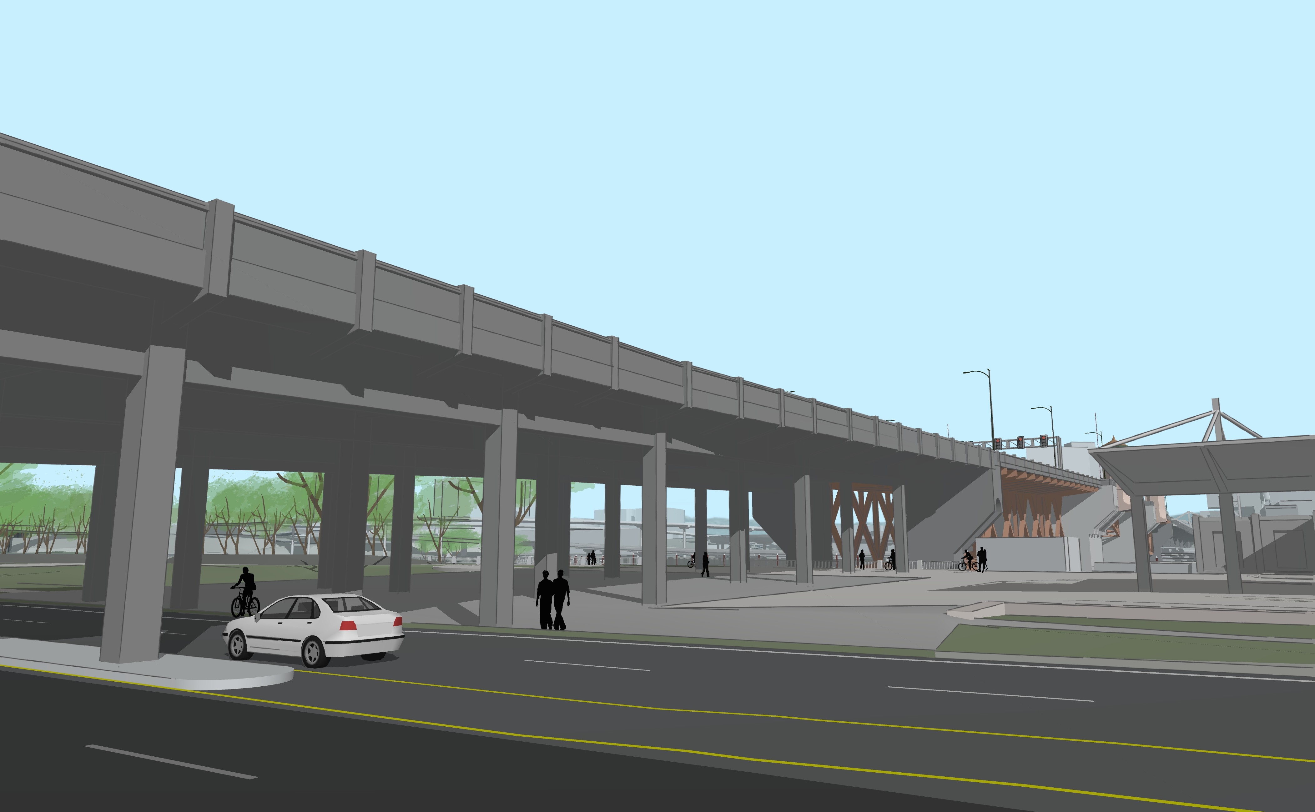
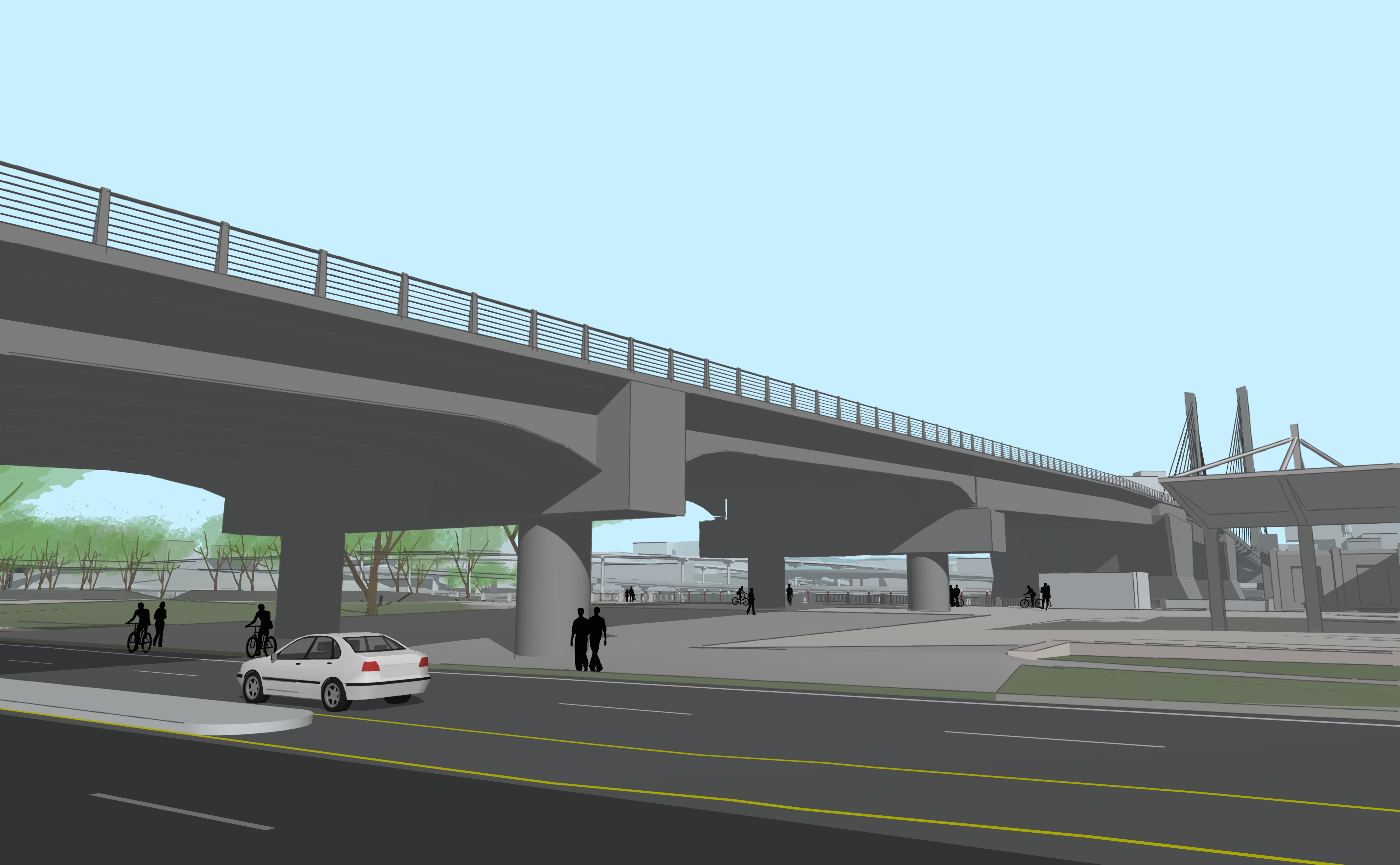
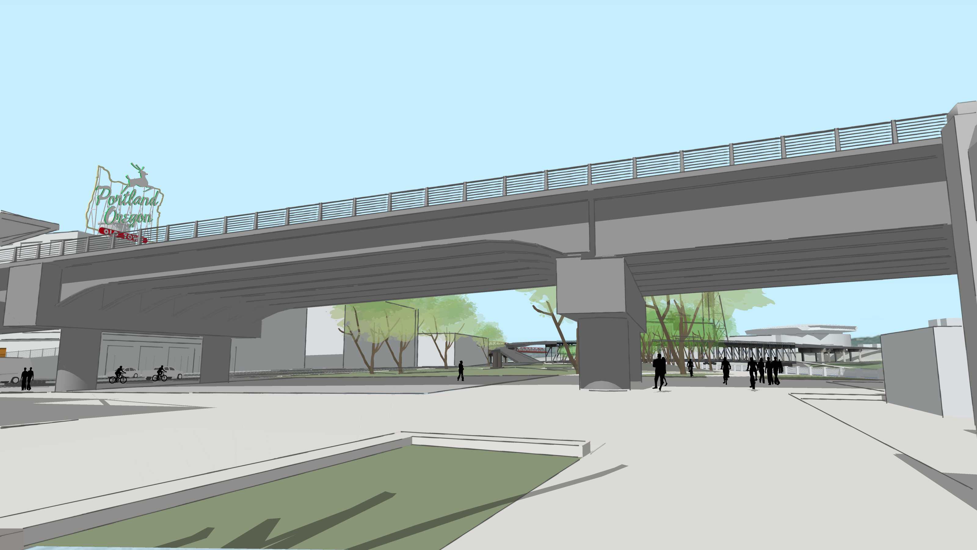
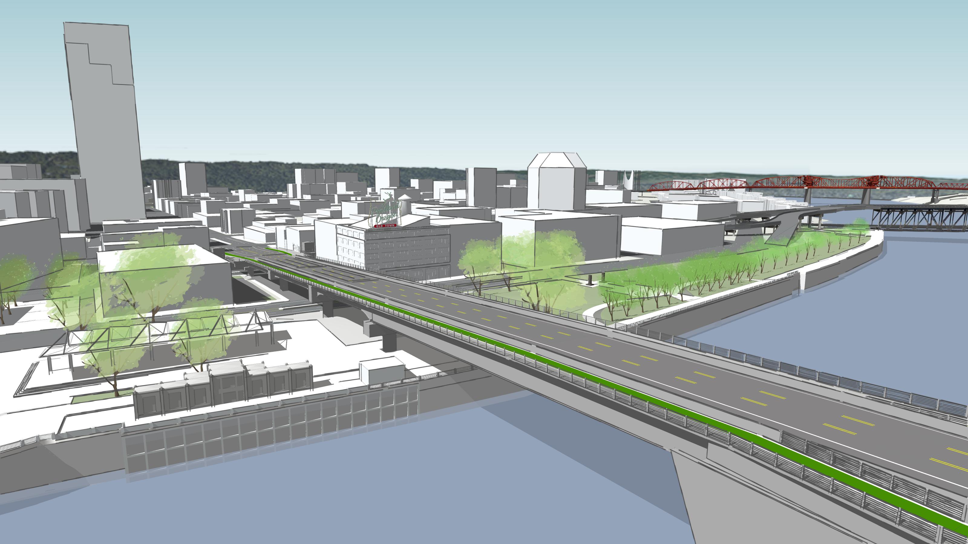
In early 2021, the project team considered several types of bridge structures for the west side: some with structures above the bridge deck along with a ‘girder’ structure type that would be open above the bridge deck, like the current bridge. Selecting a girder structure on the west side instead of a structure above the bridge would save the project $20-40 million and have the least visual impact to the historic Old Town and Chinatown neighborhood and Skidmore District.

Over the summer in 2021, feedback from government regulatory agencies and the Portland Historic Landmarks Commission indicated that any of the above-deck structure types on the west approach would have an adverse effect on the nationally recognized historic districts downtown. For this reason, building an above-deck bridge type (Tied Arch or Cable Supported) would not be permittable due to the impact on views from the historic districts.

At the beginning of the year, the girder option was not the frontrunner, in part, because the required thickness of the bridge deck would have meant lower than existing height clearances in Tom McCall Waterfront Park. Over the summer, the project team refined the girder design to be a similar thickness (or less, at many locations) to the current bridge. This would allow for better sight and visibility below the bridge than the initial girder design. The revised girder design would have two piers in Waterfront Park, rather than just one in the original Preferred Alternative, but would have more vertical clearance. The two sets of columns in the park would also be less than the five sets of the current bridge, thereby creating more horizontal space for uses below the bridge, such as the Portland Saturday Market.

While a girder for the west side of the bridge was not the most popular option in early 2021, the refined design honors the historic Old Town and Chinatown neighborhoods and Skidmore District and can meet federal requirements necessary for obtaining permits for the new bridge.

West span with the recommended girder bridge type
West span with the Tied Arch bridge type
West span with the Cable-Supported bridge type

Click the drop downs to learn more about the benefits of a refined girder on the west side of the bridge:

Refinement 3: Movable span

Movable span bridge type recommendation

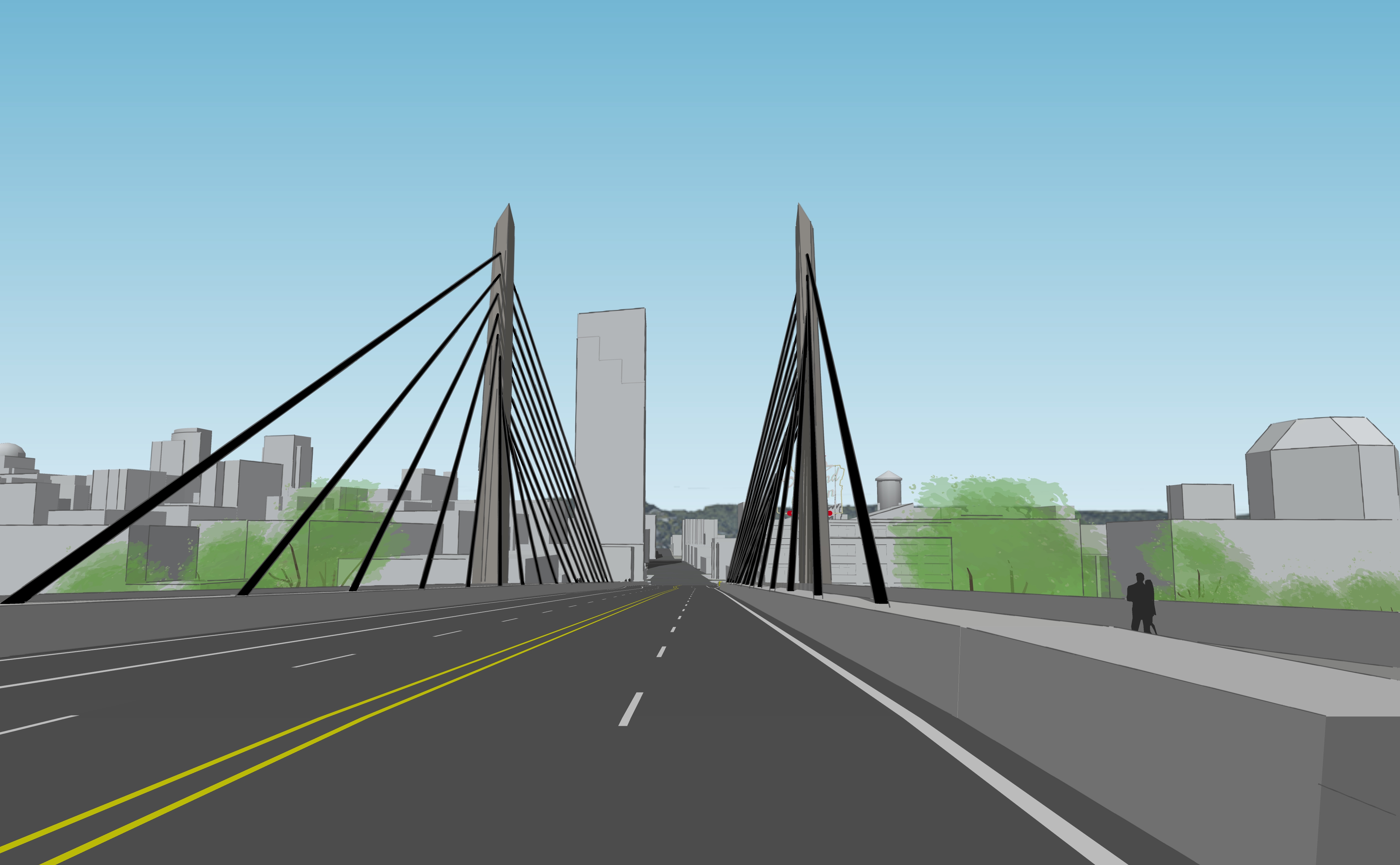
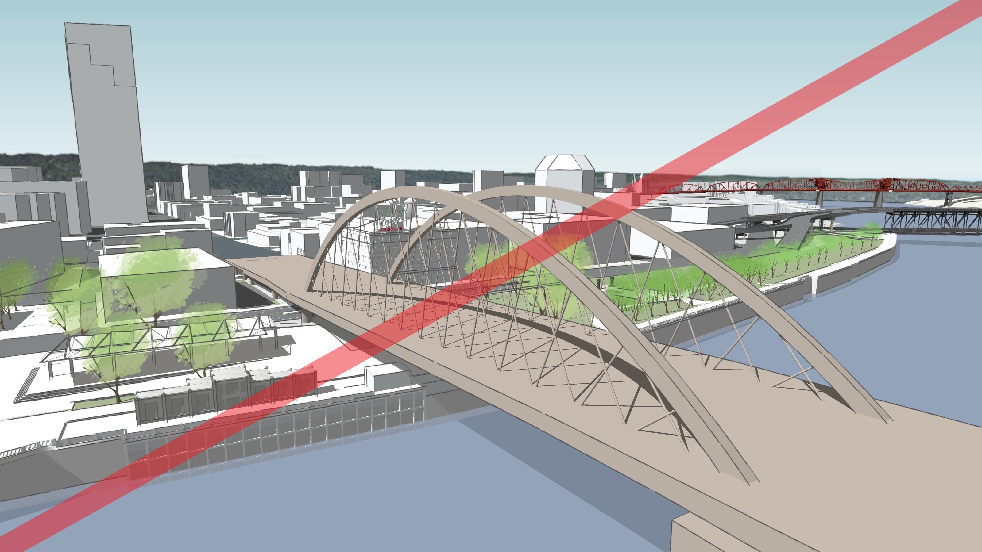
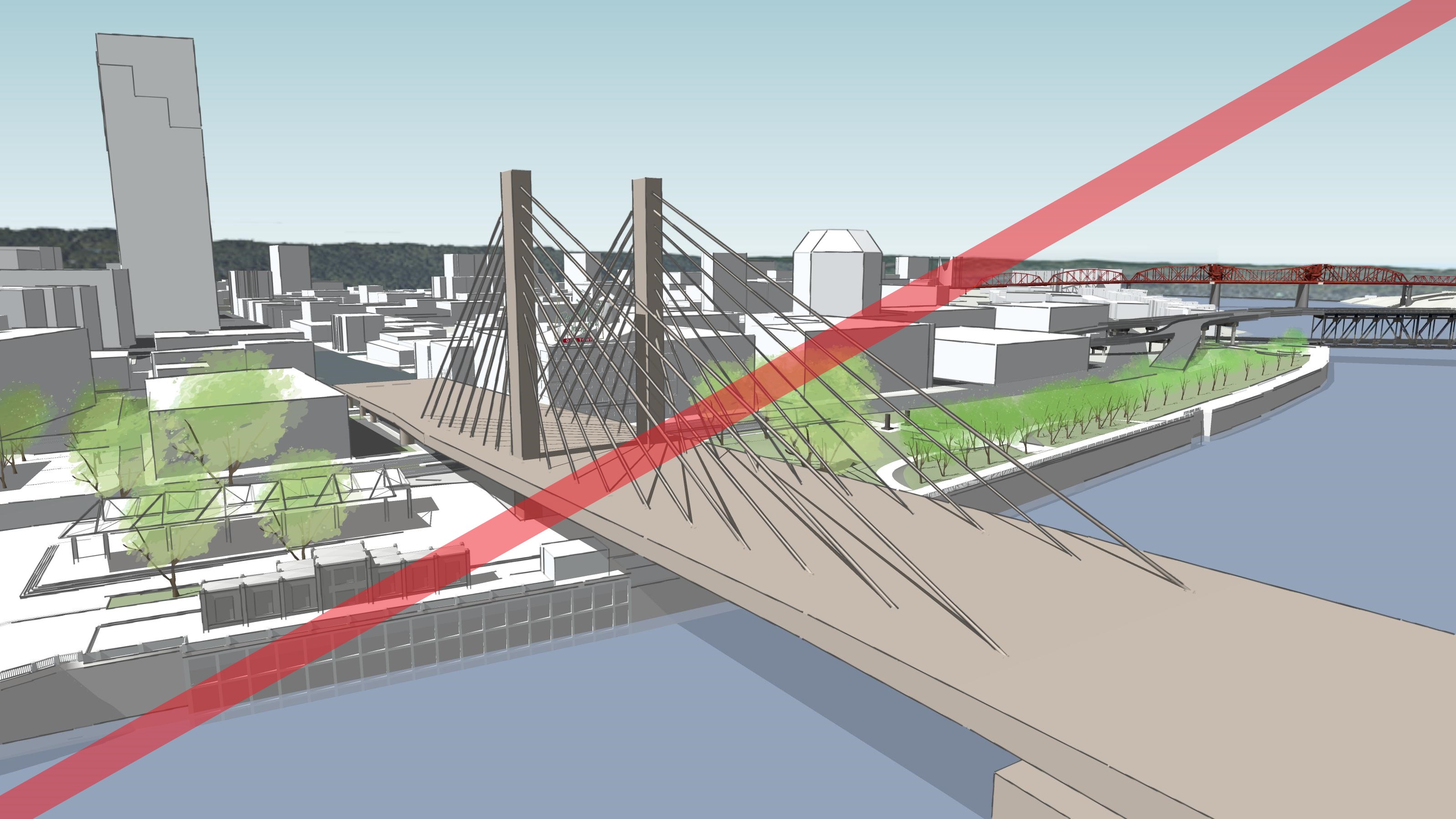
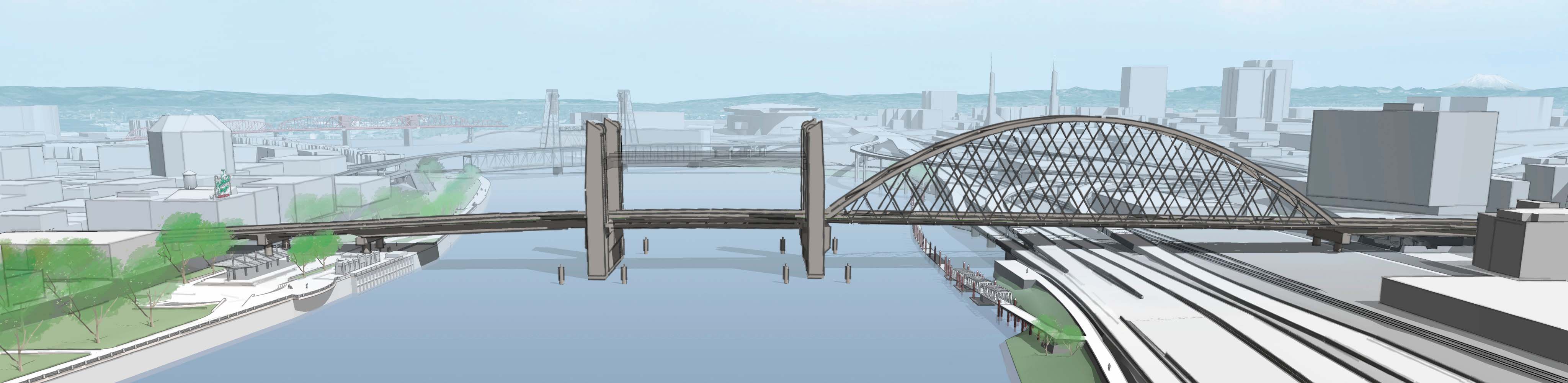
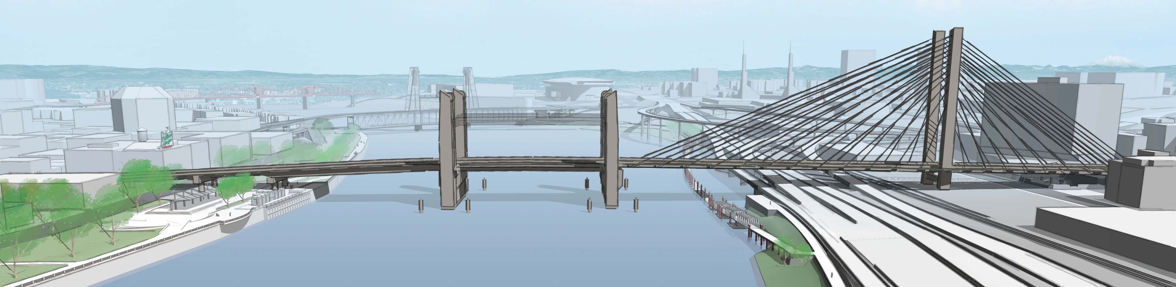
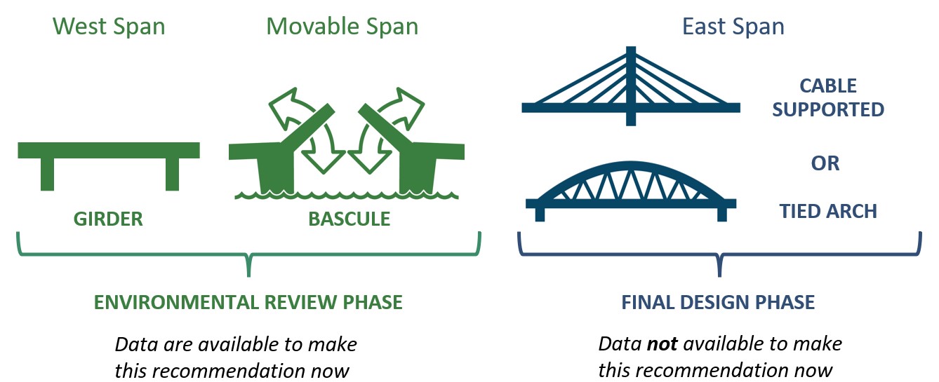
Earlier this year, we shared concepts for a variety of different bridge types - for the west approach span, the middle movable span and the east approach span. Two movable span types were considered – the vertical lift (like the Hawthorne or Steel bridges) and the bascule (like the current Burnside or Morrison bridges). We heard a strong preference from the public and key stakeholders, including the Portland Historic Landmarks Commission and Design Commission, for the bascule option for the middle span.

Given the visual prominence of the towers in the vertical lift option, federal regulatory agencies have determined this option would have adverse impacts and be less compatible with the downtown historic districts. This finding would create permitting obstacles for the project if the lift option were selected.

As part of the cost analysis, the project team found that the movable bascule option is expected to cost $25-$35 million less than the vertical lift option. Since it costs less than the lift option, has the least environmental impact to historic and cultural resources, and is preferred by the community, the project team and Community Task Force recommend the bascule-style movable span move forward into final design.

A proposal of refinements to the Burnside Bridge displays movable span options from East and West Portland with an aerial view of the city and the Willamette River. Multnomah County is considering options for bridge span types - for the west approach span, the middle movable span and the east approach span. Feedback showed great support for a bascule movable span in the middle and about equal support for the Tied Arch and Cable Supported options on the east.  
Bascule middle span and Tied Arch east span
A proposal of refinements to the Burnside Bridge displays movable span options from East and West Portland with an aerial view of the city and the Willamette River. Multnomah County is considering options for bridge span types - for the west approach span, the middle movable span and the east approach span. Feedback showed great support for a bascule movable span in the middle and about equal support for the Tied Arch and Cable Supported options on the east.  
Bascule middle span and Cable Supported east span
A proposal of refinements to the Burnside Bridge displays movable span options from East and West Portland with an aerial view of the city and the Willamette River. Multnomah County is considering options for bridge span types - for the west approach span, the middle movable span and the east approach span. Feedback showed great support for a bascule movable span in the middle and about equal support for the Tied Arch and Cable Supported options on the east.  
Vertical Lift middle span and Tied Arch east span
A proposal of refinements to the Burnside Bridge displays movable span options from East and West Portland with an aerial view of the city and the Willamette River. Multnomah County is considering options for bridge span types - for the west approach span, the middle movable span and the east approach span. Feedback showed great support for a bascule movable span in the middle and about equal support for the Tied Arch and Cable Supported options on the east.  
Vertical Lift middle span and Cable Supported east span

What else we studied and learned

Eastside Long Span Bridge Type

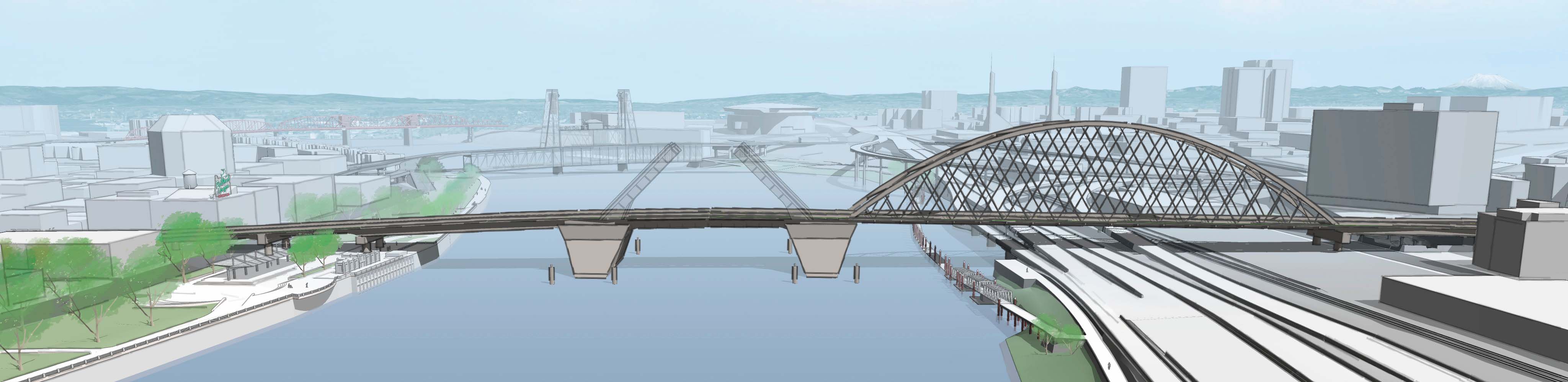
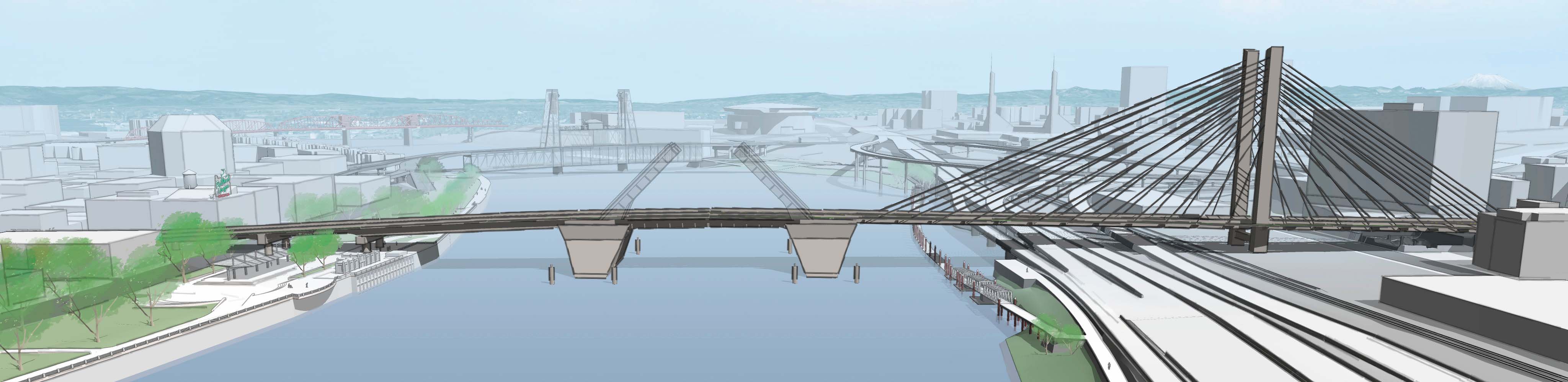
Three bridge types were evaluated for the span on the east side of the bridge—tied arch, cable supported and truss. Results of the public survey indicated very low preference for the truss, and about equal support for the tied arch and cable supported options. The truss option was eliminated in early 2021.

The project team has decided to carry the choice between the tied arch and cable supported bridge types into the final design phase, rather than to make the decision at this time. After the construction contractor is hired by the County at the beginning of final design, it will be possible for the engineering team and the contractor to work together to determine if there are any meaningful cost savings or challenges with building a tied arch versus a cable supported bridge type. Constructing this long span above the freeway, railroad, Eastbank Esplanade and the river presents unique challenges. Public input will also be considered in deciding the east span structure type during the final design phase.

A proposal of refinements to the Burnside Bridge displays an aerial view of the bridge above the Willamette River. Recent environmental technical analysis reveals that a girder structure on the westside of the bridge would not have an adverse effect on cultural and historic resources. The project team is considering cable supported options for the Eastside Long Span Bridge Type. More data will be required about the technical challenges of building over the freeway, railroad and into the large section of unstable soils on the eastside of the river before a recommendation can be made for the final design phase.

Timeline and Next steps

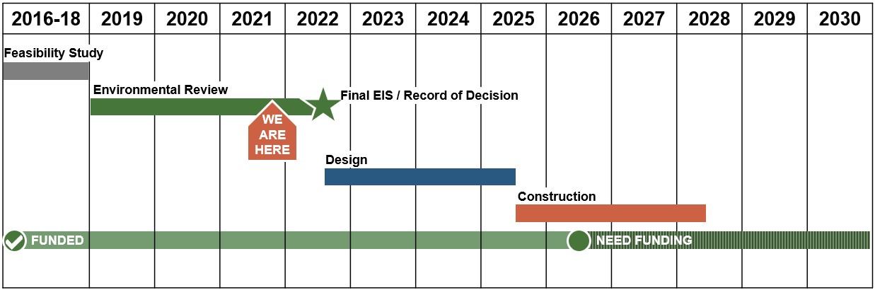
The project team will review your feedback and incorporate changes to the initial Preferred Alternative into a supplemental Environmental Impact Statement to be published in spring 2022. This will provide another opportunity for comments. Then the final decision on the Preferred Alternative to move forward into final design will be documented in the Final EIS and Record of Decision in fall 2022.

The time to do this additional analysis has pushed the start of the Final Design Phase to mid-2022. Depending on when funds are secured, construction could begin as soon as 2025. For project information, visit www.burnsidebridge.org.